This guide is for the hunter who wants an any-weapon pronghorn tag and a public-land-first plan, but does not want a public-land percentage to make the decision for them. The comparison matters now because 2026 seasons and draw results are available, and the three local Hunt Planner records expose three different access problems: Utah publishes no hunt-level land percentage, Idaho reports a large Bureau of Land Management footprint alongside military and private land, and Wyoming pairs a 90% public-land estimate with an explicit difficult-public-access warning.
The three hunts are Utah PB5049, Southwest Desert, Idaho Hunt 4012, Area 46 and Wyoming 084-1, Hunt Area 84. Each allows a rifle during its regular season, but the tag, calendar and evidence are not interchangeable. Utah is a nine-day buck-only limited-entry hunt. Idaho is a 30-day either-sex controlled hunt. Wyoming is a full-price any-antelope license with a special archery period before a 43-day regular season.
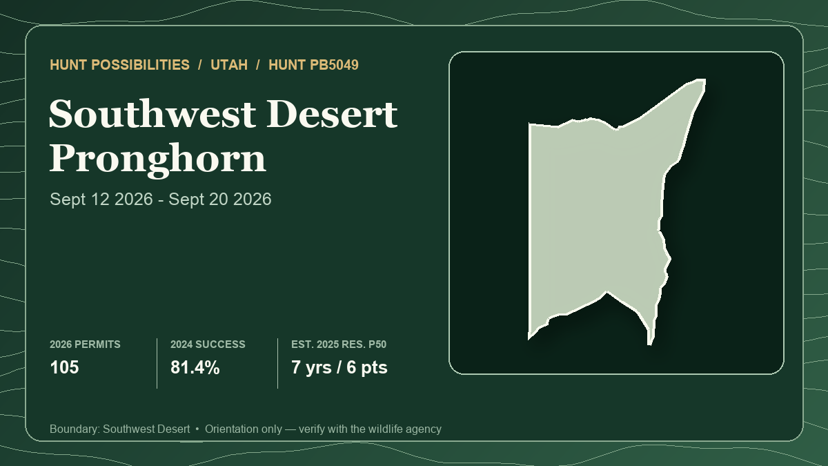
The card above represents lead hunt Utah PB5049 only, not the three-hunt comparison. Its statistics use the connected 2026 season and permit count, final 2024 harvest report and 2025 draw history. The text uses newer 2026 draw results for Idaho and Wyoming where their agencies have published them. Those year differences are deliberate.
What “public-land pronghorn” should mean
Public acreage is only the first filter. A useful public-land plan needs four things to overlap: pronghorn habitat, a legal public approach, terrain that permits observation without immediately displacing animals, and a recovery route that does not cross private or restricted ground.
The habitat pattern is broad but not generic. Utah's statewide plan says most of its pronghorn occupy shrub-steppe, commonly in large expanses of open, rolling or flat terrain, and emphasizes forbs in the forage mix. Wyoming similarly places pronghorn in flat grassland or sagebrush and gentle rolling hills. That is why small folds matter. A shallow drainage, broken bench or low ridge can hide a vehicle, hunter or final approach even when the entire basin looks open from a satellite image.
September timing changes the social picture. Wyoming says pronghorn usually breed in September. Utah PB5049 and Wyoming 084-1 open their regular seasons during that month; Idaho 4012 opens September 25 and continues through October 24. Rut activity can make bucks more mobile or visible around doe groups, but it does not create access or prevent pressure from moving animals. A herd on public land at daylight may cross private ground before a safe approach exists.
Water also needs restraint. Utah's plan says drinking-water distribution matters, especially in dry periods, while noting that moist forage can reduce direct drinking. Do not turn a mapped tank into a guaranteed tactic or publish exact water locations. Instead, compare current forage, recent moisture, fresh sign and several legal observation zones. The same caution applies to fences: they can shape movement, but they do not grant permission and should never be altered.
For every hunt below, “public land” means a starting hypothesis. Parcel continuity, road legality, seasonal closures, military or wilderness restrictions, vehicle limits and private permission still control the field plan.
Hunt 1: Utah PB5049 — a short buck hunt without a land percentage
- Current season and weapon: Buck pronghorn, any legal weapon, September 12-20, 2026. Utah approved 105 permits: 94 resident and 11 nonresident.
- Tag path or draw system: Utah limited-entry bonus-point drawing. Half of the permits allocated to each residency are bonus permits when the allocation supports that split; regular permits preserve a random path. A low-point result is not a threshold.
- Latest draw demand: The 2025 report lists 694 eligible resident applicants for 92 permits, an aggregate ratio of one permit per 7.5 applicants. It lists 760 eligible nonresidents for 10 permits, or one per 76. Resident regular permits appeared down to zero points, while the lowest nonresident point level with a permit was eight. Those isolated regular-permit results document random opportunity, not predictable odds at those point levels.
- Latest harvest result: Utah's final 2024 report lists 99 hunters afield, 81 bucks, 81.4% success and 2.9 average days. The report reflects 102 permits that year, while the 2026 allocation is 105.
- Public-land and access pattern: Neither the local record nor the current guidebook publishes a hunt-level public-land percentage. Utah explicitly says it does not guarantee access to public or private land and that unit boundaries can include private property or other exclusions. Start with the current Hunt Planner ownership layer, then verify each public block and road with the responsible land manager.
- Terrain character: The unit should be treated as a large Southwest Desert shrub-steppe problem, not one uniform basin. Open flats favor long observation; rolling ground and broken uplands provide the concealment needed for an approach. Dry conditions can make current forage and water distribution more important than a preseason pin.
- Principal tradeoff: PB5049 offers a buck-only tag, a stable 105-permit allocation from 2025 to 2026 and meaningful resident random history, but the nine-day season supplies the least schedule flexibility and the weakest hunt-level land summary.
- Best for: A Utah applicant already invested in pronghorn bonus points who can pre-verify several separated public-land systems before opening day.
Open PB5049 in the Hunt Planner 3D map.
Hunt 2: Idaho 4012 — the clearest management mix, the hardest random draw
- Current season and weapon: Either-sex pronghorn, any weapon, September 25-October 24, 2026, with 60 tags. IDFG defines “any weapon” to include rifle, archery, muzzleloader, shotgun or handgun and lists no special hunt restriction.
- Tag path or draw system: Idaho random controlled hunt; Idaho does not use preference points. A valid hunting license is required to apply, and the hunt number belongs on the application.
- Latest draw demand: IDFG's live 2026 table reports 2,400 resident first-choice applicants for 55 awards and 275 nonresident first-choice applicants for five awards, displaying 2% for both groups. Across residencies, 2,675 first-choice applicants sought 60 tags. No second-choice awards were issued in the first draw.
- Latest harvest result: IDFG reports 57 hunters, 51 pronghorn and 89% success in 2025 over 237 hunter-days, or about 4.2 days per hunter. Fifty harvested animals were horned and one was hornless. That outcome belongs to an either-sex hunt; it is not a buck-only success rate.
- Public-land and access pattern: IDFG's current surface-management summary covers about 1.7 million acres: 70% BLM, 18.1% private, 6.8% U.S. military and 4.2% State of Idaho, with smaller categories. The agency warns that management may differ from ownership. It also lists one Access Yes! property and 30,147 acres of Bruneau-Jarbidge Rivers Wilderness, about 1.8% of the hunt, where motor vehicles are not allowed.
- Terrain character: A huge high-desert mosaic of sagebrush flats, rolling benches and canyon breaks. The scale rewards several independent observation areas. Military boundaries, wilderness and private blocks can make a visually continuous landscape legally discontinuous.
- Principal tradeoff: Idaho provides the longest compact any-weapon window and the most detailed management breakdown, but the 2026 first-choice result remained about 2% for both residencies. Large BLM acreage does not make the tag attainable or every road usable.
- Best for: A hunter who prefers a fresh random chance each year and is willing to solve a complex management-and-travel map before committing to a 30-day hunt.
Open Idaho 4012 in the Hunt Planner 3D map.
Hunt 3: Wyoming 084-1 — 90% public and still marked difficult
- Current season and weapon: Any antelope, any legal weapon, September 19-October 31, 2026. The full-price Type 1 license also has an August 15-September 18 special archery period. Wyoming's final Chapter 5 sets a total quota of 150.
- Tag path or draw system: Wyoming residents enter the limited-quota resident draw. Nonresidents choose regular or special pools with preference and random components. Those pools must remain separate.
- Latest draw demand: Wyoming's 2026 resident report lists a quota of 116 against 342 first-choice applicants, about 33.9%. In the nonresident regular preference pool, seven points drew two of nine applicants, or 22.22%, and no licenses issued below seven; the regular random pool listed four licenses against 67 first-choice applicants, about 6.0%. Special-pool results differ and should not be blended with either figure.
- Latest harvest result: Wyoming's 2025 survey estimates 141 active Type 1 hunters, 110 antelope, 78% success and 5.7 days per harvest. The estimate comes from a voluntary survey and describes the full Type 1 license, including the special archery period and regular season; it is not rifle-only success.
- Public-land and access pattern: The current Hunt Planner estimates 90% public land and calls access to public land “Excellent.” The same season table marks the license type “Difficult Public Access.” Wyoming explains that such a warning can mean limited opportunity on accessible public land, high hunter density there or low antelope density. Read the two labels together: acreage is abundant, but the productive and practically reachable portion may be much smaller.
- Terrain character: The official boundary covers Wind River drainage country west of the reservation boundary, including named wildlife-management lands. Pronghorn can use open sagebrush, foothill parks and rolling country. Reservation, private and management boundaries require exact current overlays; the area description is not permission.
- Principal tradeoff: Area 84 has the strongest public-land headline, longest regular season and least restrictive recent resident result in this comparison. Its own difficult-access marker is also the clearest warning against treating 90% public as 90% easy.
- Best for: A resident or properly positioned nonresident who wants broad public-land scale and can scout where animals, legal ingress and manageable hunter pressure actually overlap.
Open Wyoming 084-1 in the Hunt Planner 3D map.
Build an access plan that survives opening day
Start by drawing several access systems, not animal pins. Each system should include a legal arrival, an observation position, at least one terrain-hidden approach and a recovery route that stays on land where the hunter may lawfully travel. Reject any system that depends on an unverified gate, a private corner crossing assumption, a military road, motorized wilderness travel or a retrieval shortcut.
Then separate visibility from stalkability. Public roadside country can hold pronghorn and still offer no safe way to close distance. Glass from far enough away that ordinary feeding continues. If animals repeatedly detect vehicles or hunters, move to a different system instead of adding pressure to the same accessible pocket.
Use wind and relief together. A favorable wind is not enough if the route puts a hunter on the skyline; a hidden drainage is not enough if it carries scent into the herd. Identify the point where both conditions become acceptable, plus a clean exit if either changes.
Plan meat care before the shot. These seasons begin in September, and warm afternoons can erase recovery margin quickly. Carry enough water for the hunter, know the distance to a legal vehicle location and avoid a shot whose likely recovery depends on crossing a boundary or driving off an authorized route.
Finally, expect the first public block to be shared. Idaho's 70% BLM summary and Wyoming's 90% public estimate can concentrate hunters on the same obvious roads, especially where private or restricted ground narrows practical access. Alternative systems in different parts of the hunt are more valuable than one heavily researched waypoint.
Best fit by hunter priority
- For the resident prioritizing the least restrictive current draw: Wyoming 084-1 showed about 33.9% resident first-choice demand in 2026, versus Idaho's displayed 2% and Utah's older 2025 aggregate ratio of one in 7.5. Different systems and years prevent treating that as a permanent ranking.
- For the hunter who refuses point debt: Idaho 4012 is the cleanest fit because its controlled draw is random. The tradeoff was 2% first-choice success for both residencies in 2026.
- For the strongest published public-land headline: Wyoming 084-1 leads at 90%, but its difficult-access marker must carry equal weight.
- For the clearest surface-management audit: Idaho 4012 publishes the most detailed breakdown, including BLM, private, military, state and wilderness shares. That detail reveals constraints rather than eliminating them.
- For a buck-only Utah strategy: PB5049 offers 105 permits and meaningful regular-draw history, but it has only nine season days and no hunt-level public percentage.
- For maximum regular-season time: Wyoming runs 43 days, Idaho 30 and Utah nine. More days help only if the usable public-land system remains legal and productive.
There is no universal winner. Utah supplies a short buck hunt with bonus and random paths, Idaho offers a random either-sex contest, and Wyoming divides residency and nonresident pools while presenting the most instructive access contradiction. The best fit is the hunt whose tag path, time window and verified usable ground align with the hunter's actual constraints.
Verification checklist before applying or hunting
- Reopen the current agency listing and confirm the exact hunt number, sex limitation, legal weapon, season dates, quota and boundary.
- Confirm the correct draw pool and application deadline. Keep Utah bonus and regular permits separate, Idaho's random drawing separate, and Wyoming's resident, regular, special, preference and random pools separate.
- Recheck ownership, legal public ingress, gates, easements, road status, fire restrictions and land-manager travel rules close to the hunt.
- In Idaho, verify military boundaries, the current Access Yes! agreement and wilderness vehicle restrictions. In Wyoming, resolve the difficult-access warning at the parcel and road level.
- Build at least three access systems with independent observation, approach and recovery plans; none should require a private shortcut or off-route vehicle use.
- Verify hunter-orange, tagging, evidence-of-sex, carcass-transport and harvest-reporting rules for the exact state and season.
- Keep terrain advice at the habitat-pattern level. Do not publish camps, water sources, private approaches, glassing positions or animal coordinates.
- Use Hunt Planner for comparison and orientation, then carry the current agency boundary and a field-ready ownership source.
The Hunt Planner methodology explains how state-specific records and data years are preserved, and the corrections page accepts source mismatches. This article was researched and drafted with AI assistance, then checked against the linked local records and official sources under the editorial and AI policy. No hunter reports are used as evidence.
Sources and verification
- Utah DWR 2026 Big Game Application Guidebook: PB5049 season and access warning
- Utah DWR April 2026 RAC packet: PB5049 resident and nonresident permit allocation
- Utah DWR 2025 limited-entry drawing odds
- Utah DWR final 2024 limited-entry pronghorn harvest report
- Utah DWR statewide pronghorn plan: shrub-steppe, forage, water and fence context
- Utah DWR Hunt Planner: PB5049 current boundary
- IDFG Hunt Planner: Hunt 4012 season, 2026 draw, 2025 harvest, surface management and access
- IDFG 2026 Big Game Seasons and Rules
- IDFG controlled-hunt information: random drawing and application process
- Wyoming Game and Fish final 2026 Chapter 5 antelope seasons
- Wyoming Game and Fish Hunt Planner: Area 84 season and public-access summary
- Wyoming Game and Fish 2026 draw reports and odds
- Wyoming Game and Fish 2026 resident antelope demand report
- Wyoming Game and Fish 2026 nonresident regular preference report
- Wyoming Game and Fish 2026 nonresident regular random report
- Wyoming Game and Fish 2025 antelope harvest report
- Wyoming Game and Fish pronghorn profile: habitat and September breeding timing
Official regulations, quotas, closures, access programs and roads can change. Utah's latest connected draw and harvest evidence is from 2025 and 2024, Idaho's is from 2026 and 2025, and Wyoming's is from 2026 and 2025. Harvest methods and samples differ, and public-land summaries do not measure reachable animals. Verify every official source again before applying and before entering the field.