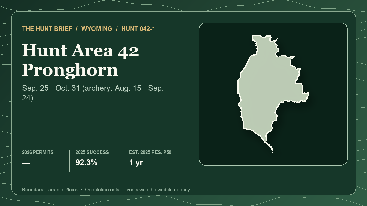
Wyoming pronghorn Hunt 042-1 closes its special-archery period today and opens to any legal weapon September 25, 2026. The headline evidence looks generous: Wyoming Game and Fish Department reports 92.3% success in 2025, and the 2026 regulations authorize 300 any-antelope licenses. The access evidence points the other way. WGFD marks the license with its difficult-public-access asterisk, rates access to public land “Poor” and estimates the hunt area at only 29% public.
That tension is the hunt. A high historical harvest rate does not mean an unprepared public-land hunter has a 92% chance. Hunt 042-1 best fits a tag holder who already has written private access or several verified, independently reachable public or Access Yes options.
Start with the static Hunt Planner profile for Hunt 042-1 and open Area 42 in the Hunt Planner 3D map. The card above uses the actual Laramie Plains hunt boundary and the local structured statistics. It is an orientation aid, not proof that a parcel, road or crossing is legal.
The quick verdict
For a current license holder, solve access before animal location. WGFD says public parcels commonly follow a checkerboard pattern, and public squares without a public-road connection are not accessible without landowner permission. Its Hunt Planner specifically recommends acquiring private access before applying. If that work is unfinished on September 24, the correct response is a narrower legal plan—not an improvised crossing on opening morning.
For a future applicant, 042-1 is no longer the relatively comfortable resident draw suggested by 2025. Resident first-choice demand jumped 35.2% in one year while the published resident quota remained 223. The harvest history remains strong, but application pressure and practical access both need to be priced into the choice.
What the 2026 license authorizes
WGFD lists 042-1 as a limited-quota Type 1 license valid for any antelope. The special-archery season runs August 15 through September 24, 2026, and the regular season runs September 25 through October 31. The regulation table sets the total quota at 300 and marks this license type for difficult public access.
A hunter participating in the special-archery period needs the appropriate antelope license and Wyoming archery license. The 2025 success figure covers the Type 1 license across the full season; it is not a firearm-only or public-land-only success rate.
Resident demand rose while quota stayed flat
WGFD's June 15, 2026 resident demand report lists 223 licenses and 438 first-choice applicants for Area 42 Type 1. The raw quota-to-first-choice ratio is 50.9%. In the comparable 2025 report, the same 223-license inventory drew 324 first-choice applicants, or a reported 68.83%.
That is 114 additional first choices, a 35.2% increase, with no increase in the published resident draw quota. It describes two completed drawings; it does not guarantee a future probability. Party applications, allocation mechanics, quota changes and applicant behavior can all change the outcome.
Nonresident pools must remain separate. In 2026, the regular random report lists eight licenses against 200 first-choice applicants, a raw 4.0% ratio. The special random report lists five against 18, or 27.8%. In the regular preference report, the last partially successful tier was WGFD's grouped “less than 8” row at 55.56%; the report shows no licenses at seven points or fewer. In the special preference report, the last partial grouped tier was below three points at an agency-reported 25%, with none at two points or fewer.
The special license changes price and draw pool, not the hunt boundary, season or access pattern. Do not blend preference, random, regular and special results into one nonresident percentage, and do not treat a historical point tier as a reservation.
What 92.3% harvest actually measures
WGFD's 2025 antelope harvest report lists 273 active Type 1 hunters in Area 42, 252 animals harvested and 665 hunter days. That is 92.3% success and 2.6 days per active hunter. The report also lists 305 licenses sold, which is not the same denominator as hunters afield.
Those are strong full-season results, but they do not identify the share taken on accessible public land, on private land or during the special-archery period. They also do not erase the access warning. A hunter with permission on productive private ground and a hunter restricted to isolated public squares are operating inside the same harvest table but facing different problems.
The latest completed harvest is from 2025; the season, quota and draw demand are from 2026. Keeping those years separate is more honest than compressing them into one opportunity score.
Checkerboard access is the controlling variable
WGFD describes Area 42 as primarily low sage and shortgrass prairie in the Shirley Basin, with little terrain variation across much of the pronghorn habitat. Elevation spans roughly 5,500 to 10,000 feet, but the agency says the Laramie Mountains portion contains little suitable pronghorn habitat. Open ground can make animals visible while leaving few concealed approaches.
The current Hunt Planner lists several Walk-In Areas, a Hunter Management Area and other managed-access properties, but a listing is not blanket permission. Each property can have its own species authorization, dates, boundary, vehicle rule and permission-slip requirement. Verify the current parcel page and map before building it into the hunt.
WGFD also warns that crowding can be a concern on reachable ground and encourages hunters to consider weekdays or later dates. Its 2026 Laramie Region forecast says pronghorn opportunity should remain similar to or better than recent years overall, while below-average spring and summer precipitation left poorer low-elevation range conditions. That regional outlook is context, not an Area 42 harvest prediction.
A legal field plan for the regular opener
- Separate the area into several independently accessible systems. For each one, confirm the public road, parcel boundary, parking authority and legal retrieval path before leaving home.
- Treat every checkerboard corner and private-road segment as closed unless current law and permission clearly establish otherwise. A public square on a map is not automatically reachable.
- Expect opening-day pressure on the obvious accessible parcels. Keep a verified midweek or later-season option instead of crowding or forcing an uncertain approach.
- Use broad habitat transitions, shallow folds and changes in vegetation height to organize observation. Do not publish or trade exact water, camps, approaches, glassing positions or animal coordinates.
- Build a wind plan. WGFD warns that extremely high fall winds can occur here; confirm conditions and effective shooting limits rather than assuming an open-country setup will remain stable.
- Do not treat animals near agricultural ground as available. Identify the exact parcel and obtain permission before making a stalk or recovery plan.
Verification checklist
- Match the license to Hunt 042-1, Type 1 and the any-antelope limitation.
- Confirm the September 25–October 31 regular season in the 2026 rules.
- Verify every public parcel, road, crossing and managed-access property against current official maps and rules.
- Carry any required Access Yes permission and respect property-specific vehicle restrictions.
- Recheck fire restrictions, weather, road status and agency notices immediately before travel.
- Keep the 2025 harvest result separate from 2026 draw demand and field conditions.
Sources and verification
- WGFD Hunt Planner: Area 42 season, difficult-access flag, public-land estimate, terrain and 2025 harvest
- WGFD 2026 antelope regulation brochure
- WGFD 2026 resident antelope demand report
- WGFD 2026 nonresident regular random antelope demand report
- WGFD 2026 nonresident regular preference-point antelope demand report
- WGFD 2026 nonresident special random antelope demand report
- WGFD 2026 nonresident special preference-point antelope demand report
- WGFD 2025 resident antelope demand report
- WGFD 2025 antelope harvest report
- WGFD 2026 statewide hunt forecast: Laramie Region
- WGFD public-access summary
Official regulations, quotas, draw reports, property enrollment, permission rules, boundaries, roads, fire restrictions and weather can change. The draw figures are from 2026, while the latest completed harvest and the card's estimated resident draw scenario are from 2025. Historical harvest does not predict an individual outcome. This article uses official agency material only and presents no hunter report as representative evidence. It was prepared with AI-assisted research and drafting, then checked against the linked sources. Read Hunt Planner's methodology, editorial and AI policy and corrections process.